
Introduction
As part of MV Moves (Active Transportation Plan), MVPC’s Transportation Program conducted data collection, intercept surveys, and abutters surveys on the various shared use paths in the region. The knowledge gained from the data collection and public engagement will inform future projects that advance the regional active transportation network. The following are the shared use paths were the intercept surveys took place.
- Salisbury East Marsh Trail
- Groveland Community Path
- Newburyport Clipper City Rail Trail
- Methuen Rail Trail
- Bradford Rail Trail
- Amesbury Riverwalk
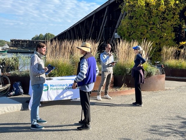
MVPC Transportation Staff Conducting Intercept Surveys along the Clipper City Rail Trail in Newburyport.
As part of the Active Transportation Plan, MVPC is forming an Active Transportation Committee who will recommend a prioritized list of concept projects that will enhance the network of paths in the region. The data and public input will inform the Active Transportation Committee’s decision-making process. A strategy of the Active Transportation Committee is to identify conceptual projects that create access to the existing network of shared use paths. The experiences of the path users who were surveyed will shape the way the region plans for future path connections.
This post reports findings from MVPC’s intercept survey data. More information will be published as MVPC’s analysis continues.
Intercept Survey Results Overview
MVPC conducted intercept surveys on six different paths in the region. Staff collected surveys from and had conversations with 99 people as they used the paths. Due to staff capacity, the times and dates of the intercept surveys varied for each path; however, the length of time spent on each path (three hours) remained consistent. The exercise was meant to capture users’ experiences as they travelled along the paths. The information MVPC collected allowed for a qualitative comparative analysis of the paths across the region. MVPC acknowledges that input was not necessarily collected from all types of users and that certain types of users are likely overrepresented.
The findings are consistent with the Impacts of Shared Use Paths study published by MassDOT.
Mode and Use Frequency
Newburyport (67%) had the highest percentage of people who walked to the paths to use the paths. The Bradford Rail Trail (43%) and the Salisbury East Marsh Trail (24%) had the highest percentage of people who biked to the paths. Groveland (75%) and Methuen (71%) had the highest percentage of people who drove to access the paths. Only one person surveyed took public transportation to a path (Bradford Rail Trail).
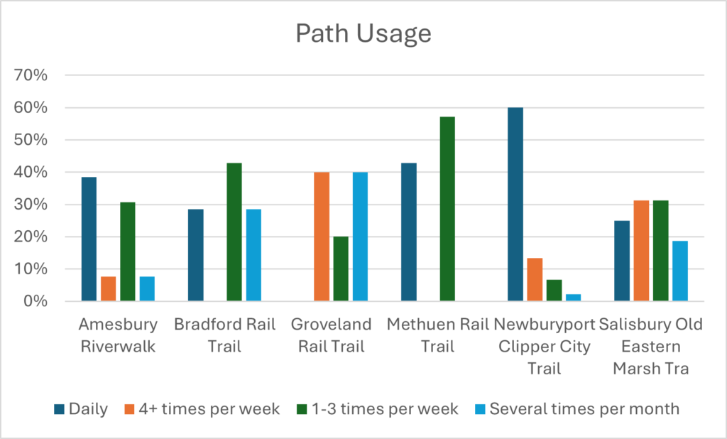
Taking all the paths into account, 61% of people who walked to the paths used the paths daily. 47% of people who biked to the paths used the paths daily. 29% of people who carpooled and 27% of people who drove use the paths daily.
Newburyport had the highest percentage (60%) of people who use the path daily. This is likely due to the connectivity between the dense neighborhoods in Newburyport and the Clipper City Rail Trail.
Use Frequency on Paths Across the Region
Time Spent on Paths
Salisbury (76%), Newburyport (69%), and Methuen (54%) had the highest percentage of people who used the paths for an hour or more. Bradford (86%), Groveland (60%), and Amesbury (54%) had the highest percentages of people using the paths for an hour or less. The length of the paths could be a contributing factor to how long people spend on the path.
Commentary from participants align well with this finding as people often stated that they would like to see the paths expand regardless of where they go. “I just want to go further” was a common statement among people using the paths for recreation.
| Path Name | Length of Path (Miles) | % of People Spending 1 hour or more on the Path |
| Salisbury Old Eastern Marsh Trail | 3.7 | 76% |
| Newburyport Clipper City Trail | 3.3 | 69% |
| Methuen Rail Trail | 2.4 | 57% |
| Groveland Rail Trail | 2 | 40% |
| Amesbury Riverwalk | 1.34 | 46% |
| Bradford Rail Trail | 0.75 | 14% |
Money Spent
Over 50% of the participants that MVPC surveyed on the Amesbury, Salisbury, and Newburyport paths responded that they either planned to or already had spent money while on their trip on the path. People reported a variety of purchased they were making. For instance, on the Amesbury Riverwalk there were folks walking to buy groceries at the CarriageTown Marketplace. In Newburyport there was one person who was walking to pick up his car from an auto repair shop. In Salisbury a couple was going to get something to eat after their bike ride.
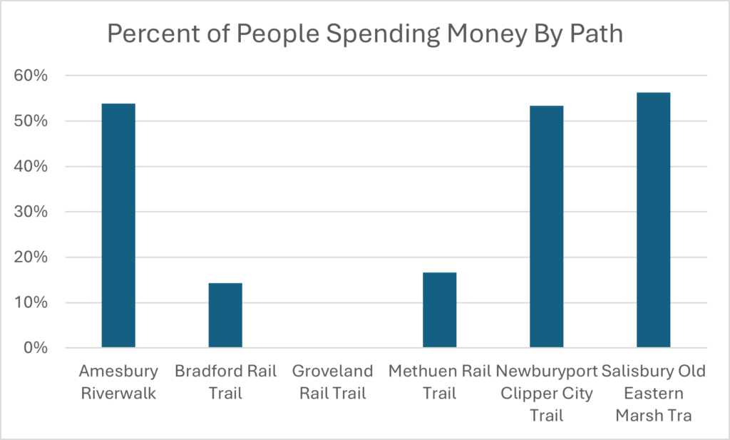
Percent of Users Who Planned on Spending or Spent Money by Path
People Commuting and Running Errands
The Amesbury Riverwalk (23%) and the Newburyport Clipper City Trail (20%) had the highest percentages of people using the path for running errands. The Bradford Rail Trail (29%) and the Amesbury Riverwalk (15%) had the highest percentage of people using the path to commute to or from school or work.
Of the people who were either using the path to commute to work or school or to run errands, 67% were walking, 22% were biking, 6% had carpooled to the path, and 6% had taken public transportation.
Comments
The paths across the region offer recreational opportunities, typically with a social component, in a safe environment void of cars. When asked what makes a path desirable, there were a variety of answers, but a common answer among users of all paths was separation for cars and the externalities of traffic. Safety and connection to other people along the paths were among the pleasant reasons for using the path. People often expressed that they felt unsafe along segments of paths that were isolated and lacked other path users. Consistent among users of all paths was a concern over the speed of e-bikes and their conflicts with pedestrians.
People in Newburyport reported that the scenic views, public art, and public spaces along the path were reasons why they enjoyed the path. In Salisbury, people reported that the connection to nature was a reason they found the path desirable. On the Newburyport Clipper City Rail Trail, a common reason for why a path was desirable was the social interactions that people have along the path. People reported making acquaintances and friendships due to seeing the same people using the path daily. The Clipper City Rail Trail offers many public spaces that allow people to stop, sit down and chat. There were several times where people milled about after taking the survey to chat with other path users after taking the survey. This experience was unique to Newburyport.
Takeaways
The connectivity of the paths to neighborhoods, accessibility of local and regional destinations, and the length of the path are factors in how often they are utilized. Connections to commercial nodes as seen along the Amesbury, Newburyport, and Salisbury paths allow people to engage in the local economy. Many people drive to the Groveland and Methuen paths because the paths lack safe connectivity to the surrounding neighborhoods. The walkable urban form of the city and the multiple access points to the Clipper City Rail Trail in Newburyport makes walking to the path desirable.
The density of the surrounding neighborhoods in Newburyport is likely a reason why more people walk to the paths and use the paths more frequently. To the same degree, the lack of density and mix of land uses in Groveland may be a reason why so few people use the Groveland Community Path as compared to the Clipper City Rail Trail.
The coastal paths network allows people to experience a more urban, commercial, and cultural setting through Newburyport then cross over the bridge to connect with nature and access parks in Salisbury. As they travel from Salisbury into Amesbury, the user once again experiences a more urban setting with historic, social, and cultural amenities. The intercept surveys have shown that the more regional connections between communities and activity nodes, the more people will walk and bike to those places. The coastal paths capitalize on the historic, cultural, commercial, and natural amenities of those communities. The Active Transportation Plan seeks to enhance those connections and create new connections so more people can enjoy the amenities the Merrimack Valley offers.
MVPC will continue to analyze the data we have collected and share our findings with the regional community as we continue our planning process. For more information and ways to engage with our active transportation planning work, please visit www.mvpc.org/atp