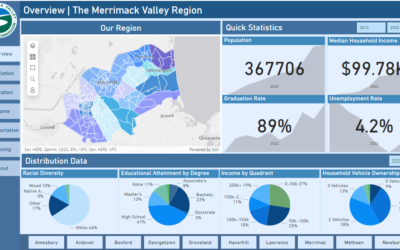
Members of MVPC’s GIS team traveled to Boston to prepare for a presentation held Monday, January 26. Steve Lopez, GIS & IT Manager; Kelsie Belanger, GIS Analyst; and Steve Wolosoff of GEI, Water Quality Practice Leader & Senior Project Manager, applied and...
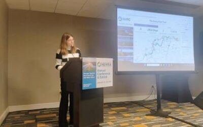
Introducing Version 3 of the Early Alert Tool
Last year, MVPC received funding as part of the Merrimack River Clean-up Initiative, providing financial backing for clean-up events and trash collection in the river. As part of this grant, we also received additional funding to further progress the Early Alert Tool,...
MVPC Releases 2025 Priority Growth Strategy
MVPC is thrilled to announce the completion of the Merrimack Valley 2025 Priority Growth Strategy, available here. The PGS serves as a guiding regional land use plan that identifies Priority Growth Areas (PGAs) across each community in the Merrimack Valley. The...
MaGICC, RPAs and MassGIS United
When geospatial data first entered the digital age, the primary goal of geospatial professionals was to obtain and convert as much data as possible to digital systems. Gone were the days of paper maps and in ushered a new era of computing and web-based systems. As...
MIMAP 3.0 Now Available
With over a year of development behind us, the GIS team at MVPC is proud to announce that version 3 of MIMAP is now available for all communities to use! When you log into your existing MIMAP application, you will now see a pop-up informing you of the change,...
Check Out MVPCs Valley Tally
If you are out and about on the active transportation network, you might have noticed some new counters on trails in Methuen, Amesbury, Salisbury and Newburyport. These trail counters are distinct from other traffic collection tools we use since they record unique...
MIMAP 3.0 Demo is Now Available
After months of hard work by the MVPC GIS team, the first publicly available demo of the third version of MIMAP has finally arrived. Featuring Groveland as our first community to make the transition, this demo is intended to give you a taste of how MIMAP looks, works,...
Revitalizing a Beloved Map: MIMAP’s Upcoming Upgrade
Originally created in 2006, MIMAP still stands as one of our most widely used applications. Since then, it has gone through a complete revision in 2015. Now a decade on, it is once again starting to show its age – some functions are no longer working as the technology...
Drone Program Soars Onwards
In May of this year, we announced that we acquired a drone – more professionally known as a UAV (unmanned aerial vehicle) – with ambitious plans to trailblaze new remote sensing projects in the Merrimack Valley. Since then, our DJI Matrice 350 RTK, affectionally named...
MVPC Launches Demographics Dashboard
The Merrimack Valley is a region full of diversity. With our fifteen communities ranging from gateway cities, suburban areas, and rural agricultural towns, there is a wide array of demographic data to explore. Last month MVPC launched a demographics dashboard. Now...


