
Lower Tower Hill Public Space Plan
Merrimack Valley Planning Commission’s (MVPC) Transportation Program is piloting a public space plan in the Lower Tower Hill neighborhood in Lawrence. Lower Tower Hill is located at the intersection of two active transportation corridors or “greenways” identified through the MVMPO’s recently endorsed active transportation plan, MV Moves. MV Moves identified regional paths that, once fully constructed, would connect people to destinations throughout the Merrimack Valley. Building on this vision of connectivity, MVPC is now focusing on how to enhance the livability of the destinations people are connecting to – ensuring that public spaces within these neighborhoods are safe, welcoming, and well-designed to support community needs.
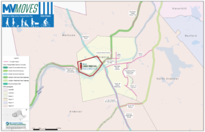
Figure 1. Location of the Lower Tower Hill Neighborhood at the intersection of the Greater Lawrence Greenway and the Northern Merrimack River Greenway.
The neighborhood public space plan focuses on enhancing the experience of people walking, biking, taking transit, and spending time in shared spaces within the Lower Tower Hill. The neighborhood is an ideal candidate for the pilot because of its high residential density, mix of land uses, access to high ridership bus routes, and its intersection with the future Lawrence Rail Trail. Most importantly, there is a need for quality infrastructure to serve the high percentage of households without access to a car and address safety concerns for the significant number of streets and intersections that appear on the regional high injury network.
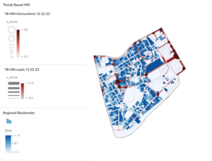
Figure 2. Map of residential density and the Regional Trends-Based High Injury Network in Lower Tower Hill. Lower Tower Hill has many residential parcels with a Dwelling Units per Acre (DUA) of 17 DUA or higher.
Charting a Path Towards Livability
At the center of livability is the idea that if you don’t want or cannot afford to own a car, you do not have to. While no single neighborhood can provide everything a household needs to thrive, it can offer the infrastructure and amenities that support the people who live there. A livable neighborhood provides multiple transportation options that grant access to a regional network of opportunities people need to achieve a satisfying quality of life for themselves and those they care about. By enhancing public spaces, the Lower Tower Hill Neighborhood can ensure that residents can reliably access transit, connect with their neighbors, walk or bike to the grocery store, and enjoy their surroundings.
What is a Public Space Plan?
The public space plan assesses the existing conditions of the neighborhood, how well it meets the needs of the community, and what the community desires from their public spaces.
A Public Space Plan Answers the questions:
- What is the vision for the neighborhood in 10 or 20 years?
- What does the neighborhood’s physical infrastructure look like today?
- What are the capital projects and policies that will achieve that vision?
By answering these questions, the plan provides a clear framework for transforming public spaces to align with community goals and long-term aspirations.
Creating a Vision for the Neighborhood
Currently, MVPC is focused on developing a vision for public spaces in Lower Tower Hill through community engagement. Staff have hosted “Favorite Places Workshops” at three community events, where attendees shared their thoughts on inspirational public spaces from around the world and discussed the public space elements they would like to see in Lower Tower Hill. Staff will host one more workshop next month at Groundwork Lawrence’s Saturday Farmer’s Market.

Figure 3. MVPC Transportation Staff at a Community Event at the Fire Station on Lowell Street in Lawrence.
To complement the workshops, MVPC launched a Favorite Places Survey, which is live and accepting responses. The survey helps identify spaces in the city that people love and why they love those spaces. The survey supplements conversations and input gathered through more direct connections with neighborhood residents.
Through the workshops and survey responses, the community has expressed that their favorite places make them feel relaxed, welcomed, and social. The vision for public spaces in the Lower Tower Hill neighborhood will be to provide those qualities and bring them within walking distance from home. Once that vision is set, MVPC and the community can begin to design public spaces that achieve that vision.
Additionally, a Community Input Map is now live, providing an interactive tool where people can pinpoint specific concerns or identify locations for potential improvements. The insights gathered though the map will help prioritize design efforts.
Assessing the Public Spaces
To ensure public space investments respond to community needs, MVPC will conduct an in-depth assessment of existing conditions of high-priority corridors, parks and other shared spaces within the study area. This assessment will provide a baseline understanding of current infrastructure, usage patterns, and potential capital projects. Data collection will be conducted using ArcGIS Field Maps on iPads, enabling efficient inventory and mapping of sidewalk conditions, public space amenities, and streetscape features.
The assessment will include:
- Sidewalk Conditions: Measuring width, materials, curb presence, and gaps in the network.
- Street Connectivity and Safety: Identifying streets with sidewalks on both sides, those with no sidewalks, and sidewalk buffer zones (2+ feet).
- Human Scale Characteristics: Evaluating the frequency of lighting, planters, street trees, bike parking, and awnings. Documenting building height-to-road width ratios, setbacks, and transparency of street walls.
- Tree Canopy Coverage: Assessing the percentage of sidewalks shaded by trees to understand comfort and heat mitigation.
- Identification of Public Spaces: Pinpointing key locations along priority corridors that serve as gathering spaces or mobility hubs.
By systematically analyzing these factors, the public space assessment will inform design improvements that enhance mobility, accessibility, and the overall experience of people navigating the neighborhood.
Community Co-Design
Once we understand the existing conditions, the vision for the neighborhood, and immediate community concerns, MVPC will invite the community to co-design workshops. MVPC will host interactive design sessions or “charettes” in priority public spaces, where residents can contribute directly to shaping improvements. Community members will be able to provide input on site-specific design considerations, and the team will translate feedback into sketches that inform design and policy recommendations. The co-design approach ensures that community members play an active role in shaping the future of Lower Tower Hill’s public spaces.
The Final Product
Following these sessions, MVPC will craft design and policy recommendations that align with existing city plans and policies while ensuring they remain responsive to community feedback and the built environment’s needs. Staff expect the final products to be completed by September 30, 2025.
Regional Livability
This plan will serve as a model for future neighborhood-level planning efforts across the region. MVPC’s active transportation vision is to integrate neighborhoods along greenways so that people can walk, bike, and take transit throughout the region and arrive at destinations that are not only accessible but also inviting, safe, and vibrant. This vision ensures these places are designed for people of all ages and abilities, foster social interaction, and incorporate transportation safety measures. MVPC’s active transportation plan will create communities where public spaces are not just points of connection, but places where people want to stay, gather, and thrive.
Learn More!
Visit MVPC’s Lower Tower Hill Public Space Plan webpage to learn more about the project and see a project timeline.